July 2025
Baseline Land Data Assimilation System for Peninsular India
SUMMARY
The Johns Hopkins University (JHU) research team joined REAL-Water in 2023 to support the water resources management research stream. Specifically, JHU took on responsibility for water resource modeling activities in India, which REAL-Water had identified as important for understanding the relationships between large-scale climate trends, evolving land use and water management strategies, and the sustainability of rural drinking water expansion initiatives under the Jal Jeevan Mission. Building from previous REAL-Water research and outreach on this topic, JHU implemented a modeling system for Peninsular India, focusing on the Cauvery, Krishna, and Godavari River basins.
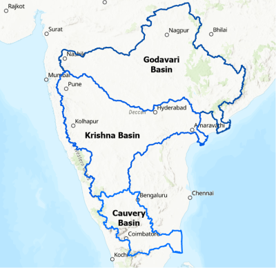
River basins in India that serve as the primary focus regions for JHU modeling activities
In JHU Project Year 1 (REAL-Water Project Year 3), we implemented a baseline modeling system, the REAL-Water India Land Data Assimilation System (LDAS), which is described in detail below. The LDAS makes use of an advanced Land Surface Model (LSM), which generates gridded estimates of water states and fluxes across Peninsular India, a river routing model that converts water fluxes into streamflow estimates, and numerous satellite-derived datasets that serve as model parameters (e.g., vegetation and land use conditions), meteorological inputs (e.g., rainfall), and evaluation datasets (e.g., soil moisture variability). The LDAS makes use of best-available global input datasets and has been evaluated using in situ meteorological and hydrological observations and satellite imagery to confirm realism at regional scale. We find that the models capture climatic gradients, seasonality, and interannual variability in hydrological conditions across the region, albeit with larger uncertainties at local scale and in highly managed landscapes. Regional-scale realism includes general agreement with a drought inventory recently produced by leading Indian experts and consistency between model output and satellite-derived hydrological estimates. The LDAS outputs are currently stored at JHU and can be shared with partners or disseminated more broadly.
We emphasize that the REAL-Water India LDAS and the retrospective simulations generated using the system are not yet optimized for local conditions or drinking water applications, and that the simulations could also be improved with better data on soil properties and land and water management. In the coming project year, we plan to implement coupling with a more detailed groundwater model that will enable analysis of local groundwater resource conditions. We are also activating an irrigation scheme to simulate agricultural impacts on groundwater resources and selecting future climate and management scenarios (e.g., increased irrigation efficiency) that we will use to simulate potential future water resource conditions. In all of this work, we anticipate close collaboration with India-based collaborators to ensure proper use of in situ data sources and effective characterization and communication of model strengths and uncertainties.
This report was part of the Rural Evidence and Learning for Water (REAL-Water) project, which was supported by a cooperative agreement between the United States Agency for International Development (USAID) and The Aquaya Institute. The contents of this post are the sole responsibility of The Aquaya Institute and do not necessarily reflect the views of USAID or the United States Government.